| Desert Peaks Section [Map, MapGL, SP] | ||||||||||||
Columns:
Land Management Climbed Rows: Suspended Peaks Delisted Peaks Colors: | ||||||||||||
| 1. Trans-Sierra — Mono and Inyo Counties | ||||||||||||
| 1.1 | Mount Patterson | Humboldt-Toiyabe National Forest | 11,673 11673' (NGVD 29) USGS 7.5' Quad (1:24,000) "Mount Patterson, CA" (1989) |
Class 1 | 4,173 | SP | W | BB | LoJ | Pb | WX | 6/17/2015 solo |
| 1.2 | Glass Mountain | Inyo National Forest | 11,140 11140' (NGVD 29) USGS 7.5' Quad (1:24,000) "Glass Mountain, CA" (1986) 11,160+ 11160-11199' (NGVD 29) USGS 7.5' Quad (1:24,000) "Glass Mountain, CA" (1994/1997) |
Class 1 | 3,210 | SP | W | BB | LoJ | Pb | WX | 6/14/2014 solo |
| ||||||||||||
| 1.3 | Boundary Peak | Inyo National Forest Boundary Peak Wilderness HP |
13,147 4007.1m (NAVD 88) NGS Data Sheet "Boundary" (HR2576) 13,140 13140' (NGVD 29) USGS 7.5' Quad (1:24,000) "Boundary Peak, NV" (1987) 13,140 13140' (MSL) USGS 15' Quad (1:62,500) "Benton, CA" (1962/1969) 13,145 13145' (MSL) USGS 60' Quad (1:250,000) "Mariposa, CA" (1963) |
Class 2 | 253 | SP | W | BB | LoJ | Pb | WX | |
| ||||||||||||
| 1.4 | Montgomery Peak ** | Inyo National Forest White Mountains Wilderness |
13,441 13441' (NGVD 29) USGS 7.5' Quad (1:24,000) "Boundary Peak, NV" (1987) |
Class 2 | 1,261 13,441 - (12,200 - 40/2) (LoJ/Pb) |
SP | W | BB | LoJ | Pb | WX | |
| 1.5 | Mount Dubois | Inyo National Forest White Mountains Wilderness |
13,559 13559' (NGVD 29) USGS 7.5' Quad (1:24,000) "Boundary Peak, NV" (1987) |
Class 2 | 2,339 | SP | BB | LoJ | Pb | WX | ||
| 1.6 | White Mountain Peak | Inyo National Forest | 14,252 4344.0m (NAVD 88) NGS Data Sheet "White Mountain Peak" (HR2559) 14,246 14246' (NGVD 29) USGS 7.5' Quad (1:24,000) "White Mtn. Peak, CA" (1994/1997) |
Class 1 | 7,196 | SP | W | BB | LoJ | Pb | WX | 7/18/2012 with John Henry |
| 1.7 | Waucoba Mountain | Inyo National Forest Inyo Mountains Wilderness HP |
11,128 3391.8m (NAVD 88) NGS Data Sheet "Waucoba" (HR2612) 11,123 11123' (NGVD 29) USGS 7.5' Quad (1:24,000) "Waucoba Mtn., CA" (1990/1995) |
Class 2 | 3,943 | W | BB | LoJ | Pb | WX | ||
| 1.8 | Mount Inyo ** | Inyo Mountains Wilderness | 10,975 10975' (NGVD 29) USGS 7.5' Quad (1:24,000) "New York Butte, CA" (1987) 11,107 11107' (MSL) USGS 15' Quad (1:62,500) "New York Butte, CA" (1950/1972) |
Class 2 | 955 | SP | BB | LoJ | Pb | WX | ||
| 1.9 | Keynot Peak | Inyo Mountains Wilderness | 11,110 3386.2m (NAVD 88) NGS Data Sheet "Monarch" (GS0832)
"The station is located on the highest peak in the Inyo Range, 11,125 feet high, and lying 10 miles airline NE of Lone Pine. From Lone Pine the peak is the central peak of three on the skyline, and has a sharp peak. Station is on the westernmost point of three on the summit of the peak, and about 4 feet lower than the highest point." (1934) "The station is located on the highest peak of the Inyo Mountains ... It is set flush about 25 yards west of and 15 feet lower than the highest point of the peak." (1950) "The station is located on a high peak locally known as Keynote Mountain in the Inyo Range, which is 10 miles northeast of Lone Pine, 25 yards west and 4 feet lower than the highest point of the mountain." (1956) 11,101 11101' (NGVD 29) USGS 7.5' Quad (1:24,000) "New York Butte, CA" (1987) 11,101 11101' (MSL) USGS 15' Quad (1:62,500) "New York Butte, CA" (1950/1972) |
Class 2 | 3,063 | SP | BB | LoJ | Pb | WX | ||
| 1.10 | New York Butte | Inyo Mountains Wilderness | 10,668 10668' (NGVD 29) USGS 7.5' Quad (1:24,000) "New York Butte, CA" (1987) 10,668 10668' (MSL) USGS 15' Quad (1:62,500) "New York Butte, CA" (1950/1972) |
Class 1 | 1,168 | BB | LoJ | Pb | WX | |||
| 1.11 | Pleasant Point | BLM Ridgecrest | 9,690 9690' (NGVD 29) USGS 7.5' Quad (1:24,000) "Cerro Gordo Peak, CA" (1987) |
Class 1 | 1,150 9,690 - (8,560 - 40/2) (LoJ) |
SP | BB | LoJ | Pb | WX | ||
| 1.12 | Nelson Range HP (Galena Benchmark) |
Death Valley National Park | 7,698 2346.4m (NAVD 88) NGS Data Sheet "Galena" (GS0828) 7,696 7696' (NGVD 29) USGS 7.5' Quad (1:24,000) "Nelson Range, CA" (1987) |
Class 2 | 1,676 | SP | W | BB | LoJ | Pb | WX | |
| 1.13 | Maturango Peak | NAWS China Lake | 8,841 2694.8m (NAVD 88) NGS Data Sheet "Maturango 2" (GS0803) 8,839 8839' (NGVD 29) USGS 7.5' Quad (1:24,000) "Maturango Peak, CA" (1982/1983) |
Class 2 | 3,659 | SP | W | BB | LoJ | Pb | WX | |
| 1.14 | Argus Peak | NAWS China Lake | 6,562 6562' (NGVD 29) USGS 7.5' Quad (1:24,000) "Trona West, CA" (1983) |
Class 1 | 1,662 | W | BB | LoJ | Pb | WX | ||
| 2. Death Valley — Inyo County | ||||||||||||
| 2.1 | Last Chance Mountain | Death Valley National Park | 8,463 2579.4m (NAVD 88) NGS Data Sheet "White Top" (HQ0929) 8,456 8456' (NGVD 29) USGS 7.5' Quad (1:24,000) "Last Chance Mtn., CA" (1987) 8,456 8456' (MSL) USGS 15' Quad (1:62,500) "Magruder Mtn., NV" (1957/1964) |
Class 1 | 2,396 | SP | W | BB | LoJ | Pb | WX | |
| 2.2 | Sandy Point | Death Valley National Park | 7,062 | Class 1 | 1,642 | SP | W | BB | LoJ | Pb | WX | |
| 2.3 | Dry Mountain | Death Valley National Park | 8,674 | Class 2 | 3,614 | SP | W | BB | LoJ | Pb | WX | |
| 2.4 | Tin Mountain | Death Valley National Park | 8,953 | Class 2 | 4,013 | SP | W | BB | LoJ | Pb | WX | |
| 2.5 | Panamint Butte | Death Valley National Park | 6,584 | Class 2 | 524 | SP | BB | LoJ | Pb | WX | ||
| 2.6 | Tucki Mountain | Death Valley National Park | 6,736 2053.0m (NAVD 88) NGS Data Sheet "Death Reset" (GS0796) 6,726 6726' (NGVD 29) USGS 7.5' Quad (1:24,000) "Emigrant Canyon, CA" (1986) 6,732 6732' (NGVD 29) USGS 15' Quad (1:62,500) "Emigrant Canyon, CA" (1952/1980) |
Class 1 | 1,866 | SP | BB | LoJ | Pb | WX | ||
| 2.7 | Telescope Peak ** | Death Valley National Park HP | 11,043 3366m (NAVD 88) NGS Data Sheet "Telescope" (GS0799) 11,048 11048' (NGVD 29) USGS 7.5' Quad (1:24,000) "Telescope Peak, CA" (1998/2002) 11,049 11049' (MSL) USGS 15' Quad (1:62,500) "Telescope Peak, CA" (1952/1973) |
Class 1 | 6,188 | SP | W | BB | LoJ | Pb | WX | 6/16/2014 solo |
| ||||||||||||
| 2.8 | Sentinel Peak | Death Valley National Park | 9,637 2937.5m (NAVD 88) NGS Data Sheet "Panamint" (GS0802) 9,634 9634' (NGVD 29) USGS 7.5' Quad (1:24,000) "Panamint, CA" (1988) 9,636 9636' (MSL) USGS 15' Quad (1:62,500) "Telescope Peak, CA" (1952/1973) |
Class 1 | 1,574 | BB | LoJ | Pb | WX | 11/2/2014 with Yann and Annika | ||
| ||||||||||||
| 2.9 | Porter Peak | Death Valley National Park | 9,101 9101' (NGVD 29) USGS 7.5' Quad (1:24,000) "Panamint, CA" (1988) 9,101 9101' (MSL) USGS 15' Quad (1:62,500) "Telescope Peak, CA" (1952/1973) |
Class 1 | 521 9,101 - (8,600 - 40/2) (LoJ/Pb) |
BB | LoJ | Pb | WX | |||
| 2.10 | Manly Peak | Death Valley National Park Manly Peak Wilderness HP |
7,196 2193.3m (NGVD 29) USGS 7.5' Quad (1:24,000) "Manly Peak, CA" (1984/1985) 7,196 7196' (MSL) USGS 15' Quad (1:62,500) "Manly Peak, CA" (1950/1957) |
Class 1s3 | 2,554 2193.3m - (1420m - 10m/2) (LoJ/Pb) |
SP | BB | LoJ | Pb | WX | ||
| 2.11 | Needle Peak | Death Valley National Park | 5,803 1768.8m (NGVD 29) USGS 7.5' Quad (1:24,000) "Manly Peak, CA" (1984/1985) 5,805 5805' (MSL) USGS 15' Quad (1:62,500) "Manly Peak, CA" (1950/1957) |
Class 2 | 1,653 | BB | LoJ | Pb | WX | |||
| 2.12 | Grapevine Peak | Death Valley National Park | 8,743 2664.8m (NAVD 88) NGS Data Sheet "Grape Reset" (GS0784) 8,738 8738' (NGVD 29) USGS 7.5' Quad (1:24,000) "Grapevine Peak, NV" (1988) |
Class 1 | 4,562 8,738 - 4,176 (Pb) 4,558 8,738 - (4,200 - 40/2) (LoJ) |
SP | W | BB | LoJ | Pb | WX | |
| 2.13 | Mount Palmer | Death Valley National Park | 7,958 | Class 2 | 738 | SP | BB | LoJ | Pb | WX | ||
| 2.14 | Corkscrew Peak | Death Valley National Park | 5,804 | Class 2 | 664 | SP | BB | LoJ | Pb | WX | ||
| 2.15 | Pyramid Peak | Death Valley National Park | 6,703 | Class 2 | 3,723 | SP | W | BB | LoJ | Pb | WX | |
| 2.16 | Smith Mountain | Death Valley National Park | 5,915 1803.0m (NAVD 88) NGS Data Sheet "Smith Mountain" (GS0906)
(West Summit)
"The station is located about 32 miles air line southeast of
Furnace Creek and about 1/8 mile west southwest of and 25 feet
lower than the highest point of the Smith Mountains."
5,913 5913' (NGVD 29) USGS 7.5' Quad (1:24,000) "Gold Valley, CA" (1988)
(West Summit)
5,880+ 5880-5919' (NGVD 29) USGS 7.5' Quad (1:24,000) "Gold Valley, CA" (1988)
(East Summit)
5,912 5912' (MSL) USGS 15' Quad (1:62,500) "Funeral Peak, CA" (1951/1973)
(West Summit)
5,960+ 5960-5999' (MSL) USGS 15' Quad (1:62,500) "Funeral Peak, CA" (1951/1973)
(East Summit)
|
Class 1 | 1,613 | SP | W | BB | LoJ | Pb | WX | |
| ||||||||||||
| 2.17 | Eagle Mountain | Resting Spring Range Wilderness | 3,811 1161.7m (NAVD 88) NGS Data Sheet "Eagle Mountain Target" (GS0871) 3,806 3806' (NGVD 29) USGS 7.5' Quad (1:24,000) "Eagle Mtn., CA" (1988) 3,806 3806' (MSL) USGS 15' Quad (1:62,500) "Eagle Mtn., CA" (1951/1966) |
Class 3 | 1,666 | SP | BB | LoJ | Pb | WX | ||
| 2.18 | Brown Peak | Death Valley National Park | 4,947 1507.7m (NAVD 88) NGS Data Sheet "Evelyn" (GS0872) 4,947 4947' (NGVD 29) USGS 7.5' Quad (1:24,000) "Deadman Pass, CA" (1987) 4,947 4947' (MSL) USGS 15' Quad (1:62,500) "Eagle Mtn., CA" (1951/1966) |
Class 2 | 1,684 | SP | W | BB | LoJ | Pb | WX | |
| 2.19 | Stewart Point | Resting Spring Range Wilderness HP | 5,265 1604.7m (NGVD 29) USGS 7.5' Quad (1:24,000) "Stewart Valley, CA" (1984) 5,264 5264' (MSL) USGS 15' Quad (1:62,500) "Stewart Valley, CA" (1958/1964) |
Class 2 | 2,394 1604.7m - (880m - 10m/2) (LoJ/Pb) |
SP | W | BB | LoJ | Pb | WX | |
| 2.20 | Pahrump Point | Nopah Range Wilderness | 5,740 1749.6m (NGVD 29) USGS 7.5' Quad (1:24,000) "Twelvemile Spring, CA" (1984) 5,740 5740' (MSL) USGS 15' Quad (1:62,500) "Stewart Valley, CA" (1958/1964) |
Class 2 | 344 | SP | W | BB | LoJ | Pb | WX | |
| 2.21 | Nopah Range HP | Nopah Range Wilderness HP | 6,394 1948.9m (NGVD 29) USGS 7.5' Quad (1:24,000) "Nopah Peak, CA" (1984) |
Class 2 | 3,589 1948.9m - (860m - 10m/2) (LoJ/Pb) |
SP | W | BB | LoJ | Pb | WX | |
| ||||||||||||
| 2.22 | Canyon Point | Death Valley National Park | 5,890 5890' (NGVD 29) USGS 7.5' Quad (1:24,000) "Harris Hill, CA" (1986/1987) 5,890 5890' (MSL) USGS 15' Quad (1:62,500) "Marble Canyon, CA" (1951/1972) |
Class 1 | 1,110 | W | BB | LoJ | Pb | WX | ||
| 3. San Bernardino County | ||||||||||||
| 3.1 | Avawatz Peak | Avawatz Mountains Wilderness HP | 6,158 1876.9m (NAVD 88) NGS Data Sheet "Avawatz" (FT1472) 6,154 1875.8m (NGVD 29) USGS 7.5' Quad (1:24,000) "Sheep Creek Spring, CA" (1996/1998) 6,154 6154' (MSL) USGS 15' Quad (1:62,500) "Avawatz Pass, CA" (1951) |
Class 1 | 3,304 1875.8m - (2,860 - 20/2) (LoJ/Pb) |
SP | W | BB | LoJ | Pb | WX | |
| 3.2 | Kingston Peak | Kingston Range Wilderness HP | 7,336 2236m (NGVD 29) USGS 7.5' Quad (1:24,000) "Kingston Peak, CA" (1984/1985) 7,323 7323' (NGVD 29) USGS 15' Quad (1:62,500) "Kingston Peak, CA" (1955/1975) |
Class 2 | 3,753 2236m - 1092.1m (LoJ) 3,743 2236m - (1100m - 10m/2) (Pb) |
SP | W | BB | LoJ | Pb | WX | |
| 3.3 | Clark Mountain | Mojave National Preserve HP | 7,933 2418.1m (NAVD 88) NGS Data Sheet "Clark" (FS1316) 7,907+ 2410-2419m (NGVD 29) USGS 7.5' Quad (1:24,000) "Clark Mtn., CA" (1985) 7,929 7929' (NGVD 29) USGS 15' Quad (1:62,500) "Clark Mountain, CA" (1956/1975) |
Class 3 | 4,281 (2410m + 10m/2) - (1120m - 20m/2) (Pb) 4,287 7,929 - (1120m - 20m/2) (LoJ) |
SP | W | BB | LoJ | Pb | WX | |
| 3.4 | New York Mountains HP | Mojave National Preserve | 7,536 2296.9m (NAVD 88) NGS Data Sheet "New York 2" (FS1400) 7,532 2295.8m (NGVD 29) USGS 7.5' Quad (1:24,000) "Ivanpah, CA" (1983/1985) 7,532 7532' (MSL) USGS 15' Quad (1:62,500) "Ivanpah, CA" (1956/1963) |
Class 3 | 3,349 | SP | W | BB | LoJ | Pb | WX | |
| 3.5 | Old Dad Mountain | Mojave National Preserve | 4,253 1296.2m (NAVD 88) NGS Data Sheet "Old Dad Mountain" (FS1269) 4,252 1295.9m (NGVD 29) USGS 7.5' Quad (1:24,000) "Old Dad Mountain, CA" (1983) 4,250 4250' (MSL) USGS 15' Quad (1:62,500) "Old Dad Mountain, CA" (1956/1974) |
Class 2 | 1,217 1295.9m - (930m - 10m/2) (LoJ) |
W | BB | LoJ | Pb | WX | ||
| 3.6 | Mitchell Point | Mojave National Preserve | 7,051 2149.1m (NAVD 88) NGS Data Sheet "Mitchell" (EU1232) 7,048 2148.2m (NGVD 29) USGS 7.5' Quad (1:24,000) "Fountain Peak, CA" (1985) 7,048 7048' (NGVD 29) USGS 15' Quad (1:62,500) "Flynn, CA" (1956/1978) |
Class 2 | 913 2148.2m - (1880m - 20m/2) (LoJ) |
SP | W | BB | LoJ | Pb | WX | |
| 3.7 | Edgar Peak | Providence Mountains SRA HP | 7,162 2183m (NGVD 29) USGS 7.5' Quad (1:24,000) "Fountain Peak, CA" (1985) |
Class 2 | 2,224 2183m - (1510m - 10m/2) (LoJ/Pb) |
SP | W | BB | LoJ | Pb | WX | |
| 3.8 | Granite Mountains HP (Granite Peak) |
Mojave National Preserve | 6,762 2061m (NGVD 29) USGS 7.5' Quad (1:24,000) "Bighorn Basin, CA" (1984/1985) |
Class 2 | 2,808 | SP | W | BB | LoJ | Pb | WX | |
| 3.9 | East Ord Mountain | BLM Barstow | 6,168 6168' (NGVD 29) USGS 7.5' Quad (1:24,000) "Ord Mountain, CA" (1982/1993) |
Class 1 | 1,508 6,168 - (4,680 - 40/2) (LoJ/Pb) |
SP | W | BB | LoJ | Pb | WX | 3/24/2017 solo |
| ||||||||||||
| 3.10 | Old Woman Mountains HP | Old Woman Mountains Wilderness HP | 5,327 1623.8m (NAVD 88) NGS Data Sheet "Woman" (EU1107) 5,325 1623m (NGVD 29) USGS 7.5' Quad (1:24,000) "Old Woman Statue, CA" (1985) 5,326 5326' (MSL) USGS 15' Quad (1:62,500) "Essex, CA" (1956/1965) 5,326 5326' USGS 60' Quad (1:250,000) "Needles, CA" (1956/1972) |
Class 2 | 2,741 | SP | W | BB | LoJ | Pb | WX | |
| 3.11 | Sheep Hole Mountains HP | Sheephole Valley Wilderness HP | 4,593+ 1400-1409m (NGVD 29) USGS 7.5' Quad (1:24,000) "Dale Lake, CA" (1985/1995) 4,613 4613' (MSL) USGS 15' Quad (1:62,500) "Dale Lake, CA" (1956/1963) |
Class 2 | 2,231 (1400m + 10m/2) - (730m - 10m/2) (LoJ) 2,234 4,613 - (730m - 10m/2) (Pb) |
SP | W | BB | LoJ | Pb | WX | |
| 3.12 | Stepladder Mountains HP | Stepladder Mountains Wilderness HP | 2,927 892m (NGVD 29) USGS 7.5' Quad (1:24,000) "Stepladder Mountains, CA" (1985) 2,920+ 890-899m (NGVD 29) USGS 7.5' Quad (1:24,000) "Stepladder Mountains, CA" (1985) 2,951 2951' (MSL) USGS 15' Quad (1:62,500) "Stepladder Mts., CA" (1956/1964) |
Class 2 | 787 (890m + 10m/2) - (660m - 10m/2) (LoJ) |
SP | W | BB | LoJ | Pb | WX | |
| 3.13 | Chemehuevi Peak | Chemehuevi Mountains Wilderness HP | 3,697 1126.9m (NAVD 88) NGS Data Sheet "Chemehuevis" (EU1077) 3,694 3694' (MSL) USGS 7.5' Quad (1:24,000) "Chemehuevi Peak, CA" (1971/1973) |
Class 2 | 1,794 3,694 - (1,920 - 40/2) (LoJ/Pb) |
SP | W | BB | LoJ | Pb | WX | |
| 3.14 | Turtle Mountains HP | Turtle Mountains Wilderness HP | 4,298+ 1310-1319m (NGVD 29) USGS 7.5' Quad (1:24,000) "Mopah Peaks, CA" (1985) 4,313 4313' (MSL) USGS 15' Quad (1:62,500) "Turtle Mountains, CA" (1954/1974) |
Class 2 | 2,690 (1310m + 10m/2) - (500m - 10m/2) (LoJ/Pb) |
SP | W | BB | LoJ | Pb | WX | |
| 3.15 | Mopah Point | Turtle Mountains Wilderness | 3,530 1076m (NGVD 29) USGS 7.5' Quad (1:24,000) "Mopah Peaks, CA" (1985) |
Class 3 | 955 1076m - (790m - 10m/2) (LoJ) |
SP | W | BB | LoJ | Pb | WX | |
| ||||||||||||
| 3.16 | Whipple Mountains HP | Whipple Mountains Wilderness HP | 4,132 1259.3m (NAVD 88) NGS Data Sheet "Axtel" (EU0995) 4,130 4130' (MSL) USGS 7.5' Quad (1:24,000) "Whipple Mts. SW, CA" (1970/1973) 4,131 4131' (MSL) USGS 15' Quad (1:62,500) "Whipple Mts., CA" (1950/1971) |
Class 1 | 2,800 | SP | W | BB | LoJ | Pb | WX | |
| 4. Riverside County | ||||||||||||
| 4.1 | Martinez Mountain | San Bernardino National Forest Santa Rosa Wilderness Santa Rosa and San Jacinto Mountains NM |
6,562 6562' (NGVD 29) USGS 7.5' Quad (1:24,000) "Martinez Mountain, CA" (1996/1999) 6,560+ 6560-6599' (NGVD 29) USGS 7.5' Quad (1:24,000) "Martinez Mountain, CA" (1996/1999) |
Class 2 | 1,702 6,562 - (4,880 - 40/2) (LoJ) |
W | BB | LoJ | Pb | WX | ||
| 4.2 | Rabbit Peak #2 ** | Santa Rosa Wilderness Santa Rosa and San Jacinto Mountains NM |
6,640+ 6640-6679' (NGVD 29) USGS 7.5' Quad (1:24,000) "Rabbit Peak, CA" (1959/1980) |
Class 2 | 1,240 | SP | W | BB | LoJ | Pb | WX | |
| 4.3 | Rosa Point | Anza-Borrego Desert State Park | 5,000+ 5000-5039' (NGVD 29) USGS 7.5' Quad (1:24,000) "Fonts Point, CA" (1959/1977) 5,038 5038' (MSL) USGS 15' Quad (1:62,500) "Rabbit Peak, CA" (1959/1961) |
Class 2 | 280 | SP | W | BB | LoJ | Pb | WX | |
| 4.4 | Pinto Mountain | Joshua Tree National Park | 3,985 1214.7m (NAVD 88) NGS Data Sheet "Pinto" (DW1491) 3,983 3983' (NGVD 29) USGS 7.5' Quad (1:24,000) "Pinto Mountain, CA" (1986/1987) |
Class 1 | 1,253 | SP | W | BB | LoJ | Pb | WX | 4/19/2017 with Angie, Sam, and Yann |
| ||||||||||||
| 4.5 | Eagle Mountains HP | Joshua Tree National Park | 5,347 1629.8m (NAVD 88) NGS Data Sheet "Eagle" (DW1480) 5,350 5350' (NGVD 29) USGS 7.5' Quad (1:24,000) "Hayfield, CA" (1987) |
Class 1 | 2,240 | SP | W | BB | LoJ | Pb | WX | 3/29/2018 solo |
| ||||||||||||
| 4.6 | Orocopia Mountains HP | Orocopia Mountains Wilderness HP | 3,819 1164.0m (NAVD 88) NGS Data Sheet "Orocopia" (DW1485) 3,815 3815' (NGVD 29) USGS 7.5' Quad (1:24,000) "Orocopia Canyon, CA" (1958/1991) |
Class 1 | 2,105 3,815 - (1,720 - 20/2) (Pb) 2,115 3,815 - (1,720 - 40/2) (LoJ) |
SP | W | BB | LoJ | Pb | WX | |
| 4.7 | Black Butte | Chuckwalla Mountains Wilderness HP | 4,510 1374.5m (NAVD 88) NGS Data Sheet "Butte" (DW1348) 4,504 4504' (NGVD 29) USGS 7.5' Quad (1:24,000) "Pilot Mountain, CA" (1986) |
Class 1 | 2,854 | SP | W | BB | LoJ | Pb | WX | |
| 4.8 | Bunch Benchmark (Chuckwalla Mountains) |
BLM Palm Springs | 3,451 1051.9m (NAVD 88) NGS Data Sheet "Bunch" (DW1373) 3,446 3446' (NGVD 29) USGS 7.5' Quad (1:24,000) "Chuckwalla Spring, CA" (1988) |
Class 2 | 1,426 | SP | W | BB | LoJ | Pb | WX | |
| 4.9 | Spectre Point | Joshua Tree National Park | 4,482 | Class 2 | 2,563 4,482 - (590m - 10m/2) (LoJ/Pb) |
SP | W | BB | LoJ | Pb | WX | |
| ||||||||||||
| 4.10 | Granite Mountains HP (Granite Benchmark) |
Palen-McCoy Wilderness HP | 4,356 1327.8m (NAVD 88) NGS Data Sheet "Granite" (DW1005) 4,331+ 1320-1329m (NGVD 29) USGS 7.5' Quad (1:24,000) "Palen Pass, CA" (1983/1984) 4,353 4353' (MSL) USGS 15' Quad (1:62,500) "Palen Mountains, CA" (1952/1971) |
Class 2 | 3,346 (1320m + 10m/2) - (310m - 10m/2) (Pb) 3,352 4,353 - (310m - 10m/2) (LoJ) |
SP | BB | LoJ | Pb | WX | ||
| 4.11 | Palen Mountains HP (Red Top Benchmark) |
Palen-McCoy Wilderness | 3,854 1174.6m (NAVD 88) NGS Data Sheet "Red Top" (DW1006) 3,848 1173m (NGVD 29) USGS 7.5' Quad (1:24,000) "Palen Mountains, CA" (1985) 3,851 3851' (MSL) USGS 15' Quad (1:62,500) "Palen Mountains, CA" (1952/1971) |
Class 2 | 2,336 1173m - 460.8m (LoJ) 2,355 1173m - (460m - 10m/2) (Pb) |
W | BB | LoJ | Pb | WX | ||
| 4.12 | Big Maria Mountains HP | Big Maria Mountains Wilderness HP | 3,381 3381' (NGVD 29) USGS 7.5' Quad (1:24,000) "Big Maria Mts. SW, CA" (1971/1980) |
Class 1 | 2,348 3,381 - (320m - 10m/2) (LoJ) |
SP | W | BB | LoJ | Pb | WX | |
| ||||||||||||
| 5. San Diego and Imperial Counties | ||||||||||||
| 5.1 | Indianhead | Anza-Borrego Desert State Park | 3,960+ 3960-3999' (NGVD 29) USGS 7.5' Quad (1:24,000) "Borrego Palm Canyon, CA" (1959/1984) |
Class 2 | 760 | SP | BB | LoJ | Pb | WX | ||
| 5.2 | Sombrero Peak | Anza-Borrego Desert State Park | 4,229 4229' (NGVD 29) USGS 7.5' Quad (1:24,000) "Sombrero Peak, CA" (1997/2003) 4,229 4229' (MSL) USGS 15' Quad (1:62,500) "Mount Laguna, CA" (1960/1970) |
Class 2 | 329 | SP | W | BB | LoJ | Pb | WX | |
| 5.3 | Jacumba Mountain | Anza-Borrego Desert State Park | 4,516 1376.4m (NAVD 88) NGS Data Sheet "Jacumba" (DC1901) 4,512 4512' (NGVD 29) USGS 7.5' Quad (1:24,000) "Jacumba, CA" (1997/2003) 4,512 4512' (MSL) USGS 15' Quad (1:62,500) "Jacumba, CA" (1959/1965) 4,513 4513' (MSL) USGS 15' Quad (1:62,500) "Jacumba, CA" (1939/1958) |
Class 1 | 1,292 | SP | W | BB | LoJ | Pb | WX | |
| 5.4 | Picacho Peak | BLM El Centro | 1,920+ 1920-1939' (NGVD 29) USGS 7.5' Quad (1:24,000) "Picacho Peak, CA" (1965/1975) |
Class 6 | 1,107 | SP | BB | LoJ | Pb | WX | ||
| 6. Nevada | ||||||||||||
| 6.1 | Ruby Dome | Humboldt-Toiyabe National Forest | 11,387 11387' (NGVD 29) USGS 7.5' Quad (1:24,000) "Ruby Dome, NV" (1990/1991) |
Class 2 | 4,809 | SP | W | BB | LoJ | Pb | WX | |
| 6.2 | Wheeler Peak | Great Basin National Park HP | 13,065 3982.3m (NAVD 88) NGS Data Sheet "Wheeler Peak" (JP0339) 13,063 13063' (NGVD 29) USGS 7.5' Quad (1:24,000) "Wheeler Peak, NV" (1990/1995) 13,063 13063' (MSL) USGS 15' Quad (1:62,500) "Wheeler Peak, NV" (1948/1970) |
Class 1 | 7,568 | SP | W | BB | LoJ | Pb | WX | |
| 6.3 | Arc Dome | Humboldt-Toiyabe National Forest Arc Dome Wilderness HP |
11,780 3590.7m (NAVD 88) NGS Data Sheet "Toiyabe Dome Reset" (JQ0514) 11,773 11773' (NGVD 29) USGS 7.5' Quad (1:24,000) "Arc Dome, NV" (1980/1985) 11,788 11788' USGS 60' Quad (1:250,000) "Tonopah, NV" (1956/1974) |
Class 1 | 5,233 | SP | W | BB | LoJ | Pb | WX | |
| 6.4 | Mount Jefferson | Humboldt-Toiyabe National Forest Alta Toquima Wilderness HP |
11,949 3642m (NAVD 88) NGS Data Sheet "Jeff" (JQ0584) 11,941 11941' (NGVD 29) USGS 7.5' Quad (1:24,000) "Mount Jefferson, NV" (1971/1975) 11,949 11949' USGS 60' Quad (1:250,000) "Tonopah, NV" (1956/1974) |
Class 1 | 5,871 | SP | W | BB | LoJ | Pb | WX | |
| 6.5 | Hayford Peak | Desert National Wildlife Refuge | 9,924 3024.9m (NAVD 88) NGS Data Sheet "Hayford" (GR1917) 9,912 9912' (NGVD 29) USGS 7.5' Quad (1:24,000) "Hayford Peak, NV" (1987) 9,912 9912' (MSL) USGS 15' Quad (1:62,500) "Hayford Peak, NV" (1960/1972) |
Class 1 | 5,412 | SP | W | BB | LoJ | Pb | WX | |
| 6.6 | Mount Stirling | Humboldt-Toiyabe National Forest Spring Mountains NRA Mount Stirling WSA |
8,220 2505.5m (NAVD 88) NGS Data Sheet "Mount Sterling" (GR1980) 8,219 2505m (NGVD 29) USGS 7.5' Quad (1:24,000) "Mt. Stirling, NV" (1984) 8,217 8217' (MSL) USGS 15' Quad (1:62,500) "Mt. Stirling, NV" (1957/1962) |
Class 1 | 1,017 | SP | BB | LoJ | Pb | WX | ||
| 6.7 | Charleston Peak ** | Humboldt-Toiyabe National Forest Spring Mountains NRA HP Mount Charleston Wilderness HP |
11,916 3632.0m (NAVD 88) NGS Data Sheet "Charleston" (GR1965) 11,915 3631.8m (NGVD 29) USGS 7.5' Quad (1:24,000) "Charleston Peak, NV" (1984) 11,918 11918' (MSL) USGS 15' Quad (1:62,500) "Charleston Peak, NV" (1957/1965) |
Class 1 | 8,257 3631.8m - (1120m - 10m/2) (LoJ/Pb) |
SP | W | BB | LoJ | Pb | WX | |
| 6.8 | Mummy Mountain | Humboldt-Toiyabe National Forest Spring Mountains NRA Mount Charleston Wilderness |
11,528 3513.7m (NGVD 29) USGS 7.5' Quad (1:24,000) "Charleston Peak, NV" (1984) 11,530 11530' (MSL) USGS 15' Quad (1:62,500) "Charleston Peak, NV" (1957/1965) |
Class 2 | 816 3513.7m - (3270m - 10m/2) (LoJ) |
SP | W | BB | LoJ | Pb | WX | |
| 6.9 | Potosi Mountain | Humboldt-Toiyabe National Forest Spring Mountains NRA |
8,517 2596.0m (NAVD 88) NGS Data Sheet "Olcott" (FS1016) 8,514 2595.1m (NGVD 29) USGS 7.5' Quad (1:24,000) "Potosi, NV" (1984/1985) 8,512 8512' (NGVD 29) USGS 15' Quad (1:62,500) "Shenandoah Peak, NV" (1956/1975) |
Class 2 | 3,012 | SP | W | BB | LoJ | Pb | WX | |
| 6.10 | McCullough Mountain | Avi Kwa Ame National Monument HP South McCullough Wilderness HP |
7,029 2142.5m (NAVD 88) NGS Data Sheet "McCullough" (FS1399)
Note that on the datasheet, the designation is spelled "MCCOLLOUGH",
but on the 7.5' quad, it's spelled "McCullough". 7,026 7026' (NGVD 29) USGS 7.5' Quad (1:24,000) "McCullough Mountain, NV" (1989/1990) 7,026 7026' (MSL) USGS 15' Quad (1:62,500) "McCullough Mtn., NV" (1960/1969) |
Class 1 | 2,220 7,026 - (1470m - 10m/2) (LoJ) |
SP | W | BB | LoJ | Pb | WX | |
| 6.11 | Spirit Mountain | Lake Mead NRA Spirit Mountain Wilderness HP |
5,642 1719.6m (NAVD 88) NGS Data Sheet "Spirit" (FS1078) 5,639 5639' (NGVD 29) USGS 7.5' Quad (1:24,000) "Spirit Mtn., NV" (1959/1976) |
Class 2 | 2,899 | SP | W | BB | LoJ | Pb | WX | |
| 6.12 | Moapa Peak | Mormon Mountains Wilderness | 6,471 6471' (NGVD 29) USGS 7.5' Quad (1:24,000) "Moapa Peak, NV" (1969/1985) 6,505 6505' USGS 60' Quad (1:250,000) "Las Vegas, NV" (1954/1969) |
Class 3 | 1,691 | SP | BB | LoJ | Pb | WX | ||
| 6.13 | Virgin Peak | Gold Butte National Monument HP | 8,071+ 2460-2469m (NGVD 29) USGS 7.5' Quad (1:24,000) "Virgin Peak, NV" (1983/1984) 8,075 8075' (MSL) USGS 15' Quad (1:62,500) "Virgin Peak, NV" (1958/1964) |
Class 1 | 3,215 (2460m + 10m/2) - (1490m - 10m/2) (LoJ/Pb) |
SP | W | BB | LoJ | Pb | WX | |
| ||||||||||||
| 6.14 | Bridge Mountain | Red Rock Canyon NCA Rainbow Mountain Wilderness |
6,988+ 2130-2139m (NGVD 29) USGS 7.5' Quad (1:24,000) "La Madre Spring, NV" (1984) |
Class 3 | 722 | SP | W | BB | LoJ | Pb | WX | |
| ||||||||||||
| 6.15 | Muddy Peak | Muddy Mountains Wilderness | 5,387 1642m (NGVD 29) USGS 7.5' Quad (1:24,000) "Muddy Peak, NV" (1983) 5,363 5363' (NGVD 29) USGS 15' Quad (1:62,500) "Muddy Peak, NV" (1953/1975) |
Class 3 | 876 | SP | W | BB | LoJ | Pb | WX | |
| ||||||||||||
| 7. Utah | ||||||||||||
| 7.1 | North Guardian Angel | Zion National Park | 7,395 7395' (NGVD 29) USGS 7.5' Quad (1:24,000) "The Guardian Angels, UT" (1996/2002) |
Class 4 | 715 | SP | BB | LoJ | Pb | WX | ||
| 7.2 | South Guardian Angel | Zion National Park | 7,140 7140' (NGVD 29) USGS 7.5' Quad (1:24,000) "The Guardian Angels, UT" (1996/2002) |
Class 4 | 1,205 | SP | BB | LoJ | Pb | WX | ||
| 7.3 | Navajo Mountain | Navajo Nation HP | 10,348 3154.2m (NAVD 88) NGS Data Sheet "Navajo Mtn" (HN0911) 10,346 10346' (NGVD 29) USGS 7.5' Quad (1:24,000) "Navajo Begay, UT" (1987) 10,388 10388' (MSL) USGS 15' Quad (1:62,500) "Navajo Mountain, UT" (1953/1973) |
Class 1 | 4,236 | SP | W | BB | LoJ | Pb | WX | |
| 8. Arizona | ||||||||||||
| 8.1 | Mount Tipton | Mount Tipton Wilderness HP | 7,153 2180.2m (NAVD 88) NGS Data Sheet "Tipton" (FS1023) 7,148 7148' (MSL) USGS 7.5' Quad (1:24,000) "Mt. Tipton, AZ" (1968/1971) |
Class 2 | 3,638 | SP | W | BB | LoJ | Pb | WX | |
| 8.2 | Humphreys Peak | Coconino National Forest HP Kachina Peaks Wilderness HP |
12,637 3851.8m (NAVD 88) NGS Data Sheet "Frisco" (FQ0624) 12,633 12633' (NGVD 29) USGS 7.5' Quad (1:24,000) "Humphreys Peak, AZ" (1966/1983) |
Class 1 | 6,039 12,633 - 6,594 (Pb) 6,043 12,633 - (6,600 - 20/2) (LoJ) |
SP | W | BB | LoJ | Pb | WX | |
| 8.3 | Superstition Mountain | Tonto National Forest Superstition Wilderness |
5,059 1542.1m (NAVD 88) NGS Data Sheet "Superstition" (DU2086) 5,057 5057' (NGVD 29) USGS 7.5' Quad (1:24,000) "Goldfield, AZ" (2004/2007) |
Class 2 | 1,837 | SP | W | BB | LoJ | Pb | WX | |
| 8.4 | Weavers Needle | Tonto National Forest Superstition Wilderness |
4,553 4553' (NGVD 29) USGS 7.5' Quad (1:24,000) "Weavers Needle, AZ" (2004/2007) |
Class 4 | 1,013 | SP | W | BB | LoJ | Pb | WX | |
| 8.5 | Signal Peak ** | Kofa National Wildlife Refuge Kofa Wilderness HP |
4,882 1487.9m (NAVD 88) NGS Data Sheet "Kofa 2" (DW0905) 4,877 4877' (NGVD 29) USGS 7.5' Quad (1:24,000) "Palm Canyon, AZ" (1990) 4,877 4877' (NGVD 29) USGS 15' Quad (1:62,500) "Livingston Hills, AZ" (1962/1984) |
Class 2 | 3,482 4,877 - (1,400 - 10/2) (LoJ/Pb) |
SP | W | BB | LoJ | Pb | WX | |
| 8.6 | Castle Dome Peak | Kofa National Wildlife Refuge Kofa Wilderness |
3,788 3788' (NGVD 29) USGS 7.5' Quad (1:24,000) "Castle Dome Peak, AZ" (1990) 3,788 3788' (MSL) USGS 15' Quad (1:62,500) "Castle Dome Mts., AZ" (1965/1973) |
Class 3 | 2,098 | SP | W | BB | LoJ | Pb | WX | |
| 8.7 | Kino Peak | Organ Pipe Cactus NM | 3,199 975.1m (NAVD 88) NGS Data Sheet "Tesmo" (DA1309) 3,197 3197' (NGVD 29) USGS 7.5' Quad (1:24,000) "Kino Peak, AZ" (1996/2000) 3,197 3197' (MSL) USGS 15' Quad (1:62,500) "Kino Peak, AZ" (1963/1969) |
Class 3 | 1,547 | SP | BB | LoJ | Pb | WX | ||
| 8.8 | Mount Ajo | Organ Pipe Cactus NM HP | 4,811 1466.3m (NAVD 88) NGS Data Sheet "Sierra Del Ajo" (DA1510) 4,808 4808' (NGVD 29) USGS 7.5' Quad (1:24,000) "Mount Ajo, AZ" (1996/2000) 4,808 4808' (MSL) USGS 15' Quad (1:62,500) "Mt. Ajo, AZ" (1963/1973) |
Class 2 | 2,703 | SP | BB | LoJ | Pb | WX | ||
| 8.9 | Baboquivari Peak | Baboquivari Peak Wilderness HP Tohono O'odham Nation |
7,734 7734' (NGVD 29) USGS 7.5' Quad (1:24,000) "Baboquivari Peak, AZ" (1979/1983) 7,730 7730' (MSL) USGS 15' Quad (1:62,500) "Baboquivari Peak, AZ" (1941/1955) |
Class 4 | 4,204 | SP | W | BB | LoJ | Pb | WX | |
| 9. Mexico | ||||||||||||
| 9.1 | Cerro Pescadores | 3,543+ | Class 2 | 3,412 (1080m + 20m/2) - (60m - 20m/2) (Pb) |
BB | Pb | ||||||
| ||||||||||||
| 9.2 | Pico Risco | 4,987+ | Class 3 | 394 (1520m + 20m/2) - (1420m - 20m/2) (Pb) |
SP | BB | Pb | |||||
| ||||||||||||
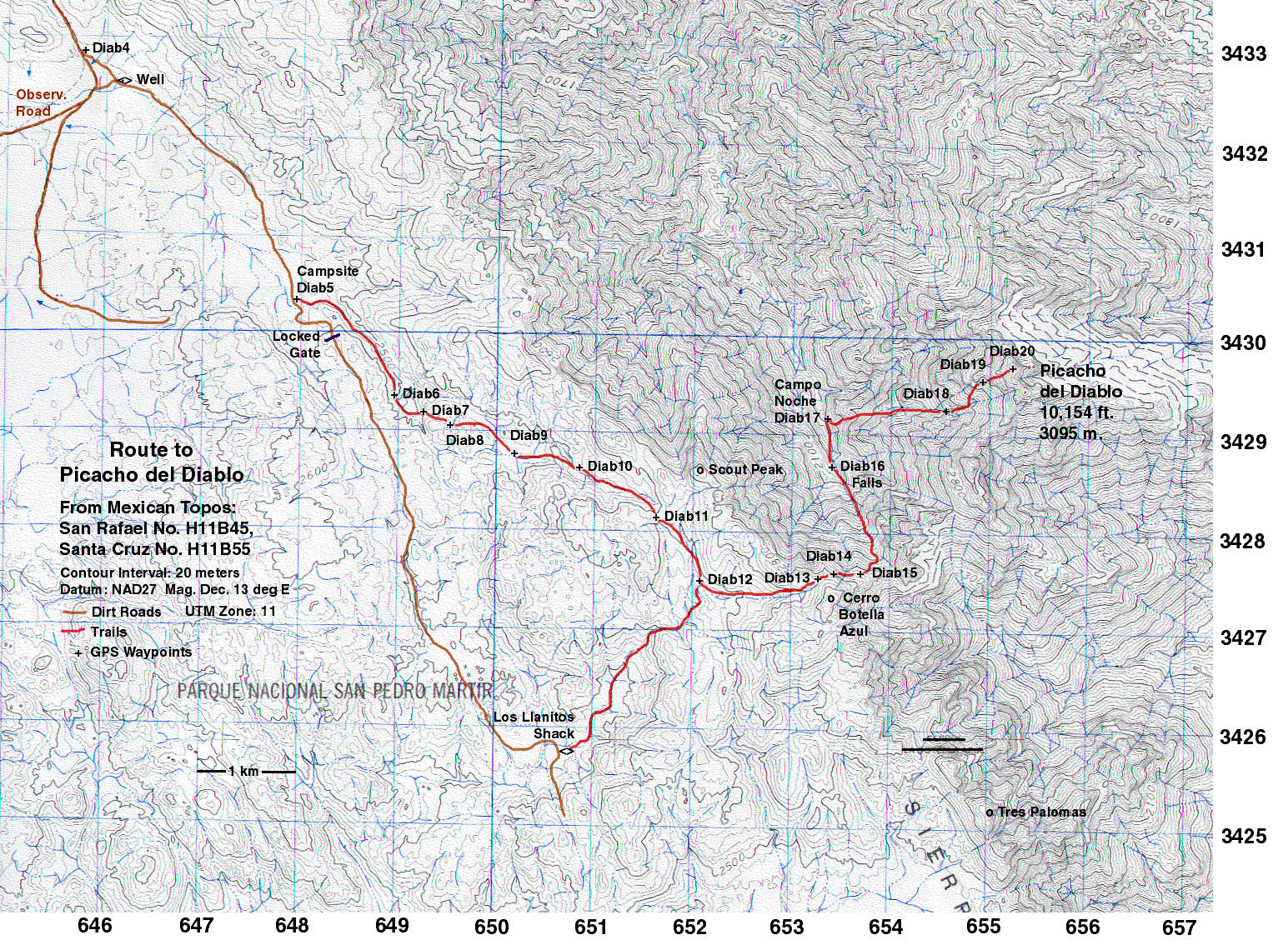
| 9.3 | Picacho del Diablo ** | 10,154 10,171+ |
Class 3 | 6,972 3095m - (980m - 20m/2) (Pb) |
SP | W | BB | Pb | ||||
| ||||||||||||
| 9.4 | Cerro del Pinacate (Cerro Pinacate) |
3,957 3,937+ 4,235 4235' (MSL) USGS 60' Quad (1:250,000) "Sonoyta, AZ" (1954) |
Class 1 | 3,215 (1200m + 20m/2) - (240m - 20m/2) (Pb) |
SP | W | BB | Pb | ||||
| ||||||||||||